A tale of self-interest, optimism, naivety, fraud, bankruptcy, incompetence, arrogance, violent deaths, royalty & religion with congratulations to the non-participants and ignorance of the achievers.
[Please read this chapter in conjunction with two others; ‘The Railway Station’ & ‘In and around the Railway Station’. ]Era Of Railway Travel
Railway travel became increasingly common during the 1800s; around the time the building of ‘Direct Line’ started, over 800 million passenger miles were travelled each year, more than that in the mid-1980s. The first commercial railway was inaugurated at Oystermouth in1807 followed by the one from Stockton to Darlington in 1825 and the first inter-city service between Liverpool & Manchester during 1830.


First commercial railway 1807 Stockton & Darlington Liverpool & Manchester Oystermouth, nr. Swansea Railway 1825 Railway 1830
Government de-regulation and the profits from the industrial revolution led to a huge increase in investment and with over 4600 miles of new lines authorised by parliament during 1847 the share prices climbed steeply to an index of 170. Many of the lines had no chance of financial viability and by 1849 the index had crashed to 60. Despite this series of events, lessons were not learnt and in 1866 City Financiers Overend & Gurney went bankrupt. The boom built around speculating in railway shares collapsed and they fell 66% in one day. Railway contractors then could not get credit with local contractor Thomas Brassey having £3M. of liabilities (£370 M. 2020).
Winners & Losers
The socio-economic & political landscapes during the 1800s were very different to today. The Peterloo Massacre in 1819, the Corn Laws from 1815 to 1846 and the conditions faced by those involved in the sweat shops & mines showed a huge disparity between those earning the wealth & the ruling elite. In 1834 the six Tolpuddle Martyrs were arrested on a legal technicality during a labour dispute against decreasing wages. At the Great Exhibition of 1851, Britain was described as ‘The Workshop Of The World’ that resulted in the ‘nouveau riche’, who in turn contributed to the ‘railway bubble’, most losing their investments. As a result of the Irish Potato Famine (1845 to 52) immigration to the United Kingdom increased the labour pool driving wages down. Labour unions were formed and though in 1873 wages increased by 20 to 25% but the workers failed to co-operate & strikes failed.
Inevitably the lack of regulation, naïve investors and the opportunities to use the political system to easily form railway companies led to fraud on a monumental scale. The second M.P. for Poole, Charles Waring is estimated to have made £60 M. (in today’s money) through being chairman or a director of a railway company, the main contractor and using his position in parliament to get the authorisation through the system. After completion he handed a bankrupt Somerset & Dorset Railway over to the share-holders and it was then known as the worst managed railway in Britain! His money-making ‘tactics’ caused some of the initial delays in getting the railway to Bournemouth.


Charles Waring Cable coming ashore 1866 6th Annual Farm Labourers Heart’s Content, Newfoundland Demonstration 1877
Locally technology was arriving with domestic gas at Lymington in 1832 and the wire telegraph during 1852. On the domestic front, tinned food arrived from America in 1860, at the second attempt during 1866 the transatlantic cable was laid and working.
Agricultural labourers demonstrated through the 1870s; in 1884, with deflation running at -2.5% this led to falling wages, especially for farm labourers.
Why Build The ‘Direct Line’?
Prior to 1830 Southampton was considered to be a fashionable watering place with a very select society, sea bathing and drinking mineral waters from natural springs. Around that time, it was less important as a port but as the activities at Lymington & Poole declined, the opening of the Southampton to Nine Elms London railway became another catalyst for growth. In 1836 the Southampton Dock Company was formed & the London to Southampton railway opened in 1838. The Hampshire Advertiser of 16 June 1838 wrote, “ the new romantic watering place of ‘Bourne’ might eventually compete with Southampton’s renown”. In 1842 the Peninsula & Oriental Company designated Southampton ‘a port of call’ making it a strategic railway destination.


Railways arrived in the local area during 1847 with the opening of ‘Castleman’s Corkscrew’ from Southampton to the ‘capital of Dorsetshire, Dorchester’. To make it financially viable it weaved between stations at all the towns from Brockenhurst to Dorchester hence the name ’corkscrew’. The nearest station to New Milton was at Holmsley, originally known as Christchurch Road (even though it was 5 miles from Christchurch!). It also included a branch line to Hamworthy near to Poole.
Capitalising on the importance of Lymington as a port, supplier of salt and the connection to the Isle of Wight, the single branch line to Brockenhurst was opened in 1858.

LSWR Lines In 1858
In December 1858 at a meeting held in Christchurch, the local M.P. Admiral Walcott protested that, “in all his 66 years he had never seen an increase in the wealth or any improvement in that town or neighbourhood…….we are stuck in a corner, having all the assets of natural beauty and scenery…..NO RAILWAY!”.
As a result, in 1862 the Ringwood to Christchurch Old Station single branch line was opened and in 1870 extended to Bournemouth East Station.
In 1872 a branch line was added from Broadstone to Poole, Branksome and on to the Bournemouth West Station. Poole was therefore well served by railways and the population increased from 5,896 in 1871 to 16,858 in 1881.
Finally, in 1885, the two Bournemouth stations were linked by a single line.
But the route to Bournemouth was circuitous involving ‘Castleman’s Corkscrew’ with its many curves thus limiting the speed of the trains. The carriage seats were hard and configured in individual compartments i.e., no toilet during the long journey!
Justifying, Lobbying and Planning The Direct Line.
With so many local lines why build another line from near Brockenhurst to Bournemouth?
Many traders and those in the growing medical profession were frustrated that potential visitors to Bournemouth were put off by the time it took to get there from London.
Let us first look at the normal process to get a line built & running.
- ‘Businessmen’ & professionals set up a company
- Appoint advisors and civil engineering contractors
- Obtain an act of parliament for the proposed line
- A prospectus is issued to raise funds via shares &/or debentures
- Gain support of an established railway company to run the line
- Plan the line to be run where there is sufficient passenger traffic
And for this line, then negotiate with powerful landowners, the Verderers, the Court of Swainmote and therefore the Crown.
By the 1880s the fraudulent activities of such persons as Charles Waring had been reported in the ‘Poole Post’. The London & South Western Railway (LSWR) decided to construct the ‘Direct Line’ themselves.
They appointed the chief engineer William Jacomb of the LSWR to plan the route. After the first planning and very brief survey in July 1882, Jacomb wrote, “No substantive difficulties would be encountered”. No doubt he had concluded that across a relatively flat area, with no lakes, wide rivers, high hills or mountains and a in benign climate, what could possibly go wrong?
The route was planned via Sway as it was the only substantial village in the area and a source of revenue. Logically, given the importance of Lymington, doubling the existing branch line from Brockenhurst and then running along the coast was a prime route but was not considered economically viable. There were probably concerns about the yellow marl clay at and around Hordle.
Physical Hurdles To Be Overcome.
So, what was known about the area in the 1880s?

Old Geological Map Of The New Forest
It can be seen in the previous image that the whole area has different kinds of clay and that whatever the route it meant crossing streams, rivers, paths, tracks & roads.
There is no evidence of even a simple soil survey being carried out. In the author’s experience it only requires basic tools and observation of the plant life supported by a basic knowledge of common species to give an indication of the soil types.


Due to the low power of the locomotives and their relatively light weight a critical, well known requirement was the maximum line gradient of 1:80.

Typical Engine Of The 1880s – Relatively Light & Low Power
Even in those days ‘leaves on the line’ was a problem exacerbated by the wheel flanges rubbing on curves and wet rail surfaces, thus underlining the need for as shallow a gradient as possible.
Furthermore, the line layout could not include level crossings or modify the angle of any streams, rivers, paths, tracks & roads that are to be crossed.
Organisations & Individuals Involved – The Great & The Good.
- Verderers (representing the Commoners) via the Court of Swainmote – they eventually agreed the route subject to the provision of bridges & subways for free access of commoner’s animals
- Andrew Peterson – owner of Newhooks (land through Mead End & Arnewood)
- Rev. Nathaniel Bond – major land owner in Sway
- Coleridge & Henry Kennard – owners of substantial properties in Milton
- Sir George Eliott Tapps-Gervis-Meyrick, 3rd Baronet of
Hinton Admiral who initially opposed the line but having substantial holdings in Bournemouth relented, following advice from his wife as to the financial advantages who in turn was briefed by Russell-Coates
- Sir Merton Russell-Cotes who took up the idea of a Direct Line after it was suggested by a Dr Nankivell in . He was a close associate of Wyndham S. Portal, deputy chairman of the LSWR and acted as a link between traders in Bournemouth and the Meyricks.


Sir George Eliott Sir Merton Russell-Cotes
Tapps-Gervis-Meyrick,
3rd Baronet
Let us now take a visual tour of the direct line stopping along the way for a raft of facts & anecdotes .
We start, not in Brockenhurst but at Lymington Junction where the Lymington Branch Line forks almost due south. The first task was to replace the existing level crossing over with a bridge to carry the Sway Road over the rails (by blue triangle).

Lymington Junction 1898 Ordnance Survey Map ‘Courtesy of the Ordnance Survey’
The start was straight forward with the bridge brick supports constructed with the distinctive cap stones over dark red bricks. The roadway is wrought iron.

Views both ways from the Sway Road bridge show a level ground from Brockenhurst and in the direction of Sway – what could possibly go wrong?


View to Brockenhurst Lymington Branch Direct Line to Sway
The image below captured in 1946 shows a steam train on the now defunct Castleman’s Corkscrew with the Direct Line and Lymington Branch Line running almost due south.

Just down the road we come to a very large and long brick bridge over a track that leads to Caters Cottage. This bridge is in the best condition of any along the line and must have cost far more than one that was just sufficient – the first unexplained and very costly item. Whoever lived at Caters Cottage had influence?


Moving in a south westerly direction a short distance further down the road and looking towards the railway can be seen what is described as a ‘cattle creep’. The internal dimensions are about 15 ft. high and 6 ft. wide far greater than a typical cattle creep (seen on the right). A second expensive feature – again who had enough influence to insist on a such an over-design?


‘Cattle Creep’ under the Direct Line Typical Cattle Creep
A short distance along the road to Sway is a huge wrought iron structure carried on very solid brick supports with enormous abutments either side. This is Latchmore Bridge that runs at an acute angle to the road thus resulting in a very long span.


It is normal practice to change the path of the road using ‘dog-legs’ so the new bridge is at right angles to the railway and thus traversing the minimum distance. BUT one of the key conditions of building the Direct Line was that the paths of roads, lanes, tracks and waterways must not be modified.
Enter Albert Chandler of Sway a Verderer who was charged with oversight of the construction of the railway.
Albert Chandler was concerned that at Latchmore, the contractor was constructing dog-legs and he reported the “cutting & destroying of pasture” to G.F.W. Mortimer, Clerk to the Court of Swainmote. The contractor claimed the ‘dog-legs’ were on the plans but the Hon. Gerald Lascelles, Deputy Surveyor of the New Forest (a Crown Appointment) sided with the Verderers and as a result the LSWR had to construct an extremely expensive and long bridge followed by many more on a lesser scale.
Accommodation Bridges
Another key condition from the Verderer’s was the provision of ‘Accommodation Bridges’ & ‘Cattle Creeps’ for the “free access of commoner’s animals”. There are three such bridges between Latchmore Bridge & Sway. These were originally constructed in wood giving a nine-foot-wide access. All that is left of the original constructions are the ramps on either side of the line. After the wood rotted away the bridges were re-built using bricks


After more road bridges is Sway Station (below), one of three originally identical versions, the others being at New Milton & Hinton Admiral.

Unfortunately, only New Milton remains in a near original state the other two having been ‘modernised’.
The Navvies
The men who built the Direct Line are known as ‘Navigators’ or ‘Navvies’. They either took lodgings locally or lived in ‘Shanty Towns’ at Sway, Fernhill Copse, Walkford & Hinton. These consisted of temporary buildings constructed by the occupants. Navvies also provided their own tools, food and travel. There were many itinerants in their ranks with locals joining to gain the pay rates compared to agricultural wages (36 d. to 48 d per day compared to 24 d. or 12d for a woman). The Hop Pole hostelry in Sway (pictured below) and The Hare & Hounds in Durnstown were popular with the navvies and reports of riots and randies led to two extra policemen being drafted in.

The Hop Pole Hostelry, Chapel Lane, Sway.
By contrast the shanty towns at Walkford & Hinton were relatively peaceful.
Due to such conditions as very sticky wet clay, problems with the brakes on wagons and toiling at night by oil lamps, the working conditions were very dangerous. After accidents doctors had to summoned from main towns such as Lymington and by the time, they arrived the patient was often dead or close to death.
There was no automatic compensation and the contractors always fought any claims, also insisting on going to court. Magistrates usually favoured the claimants but some apparent cases of negligence were judged as ‘accidental’.
Examples are given below: –
- John Clark – fell from a cart and his arm was crushed by the wheel – ‘accidental death’
- 16-year-old lad called Beer – greasing axle of tipper wagon £75 claimed, family accepted £30 from contractors Kellett & Bentley
- 23-year-old John Biddulph slipped down Ashley embankment and was run over by a number of wagons – ‘accidental death’
- Alfred Whitcher from Bashley on his first night was buried alive in the clay – £200 claimed, negligence was proven & £150 awarded.
Of the ten navvies killed on the line, two are buried in Sway churchyard but only one gravestone still exists, that of Frederick William Clark, 22 years who was killed on 30/8/86 when he was flung from a truck that left the rails at high speed. Doubts were raised at the inquest in line with the interpretation of the Employer’s Liability Act 1880. In May 1887 Frederick’s widow took the contractor to the County Court and the brake handle was proved to have been faulty. 3 years pay was awarded (£150) with £6 for the headstone shown below.


The attitude to navvies varied widely; the Medical Officer of the Rural Sanitary Authority recorded, “the annual death rate has risen from 14 ½ to 18 ½ per thousand due to the great influx of people on the railway works”.
Crime increased but this was usually high jinks due to the amount of beer drunk. After the New Forest Shakers were evicted from New Forest Lodge (Hordle Grange), in Vaggs Lane, they set up an encampment in Tiptoe. It was fashionable for ladies from Bournemouth to visit them by char-a-banc. A Mrs Quirk had a cloak and an umbrella stolen by a navvy called George Williams. He received a sentence of one month’s hard labour a somewhat ironic sentence for a navvy.
To try and reduce Friday night drunkenness local groups organised parties with light refreshments, readings, singing & addresses. At Christmas local people made collections to ensure navvies and their families had presents.
On Queen’s Jubilee day, Tuesday 1st of June 1887 Louisa Marchioness of Waterford hosted a substantial ‘meat tea’ for 123 navvies and their families at Highcliffe Castle.
The Great Mistake With Lasting Consequences
Just west of Sway is a short embankment just ½ a mile long with much longer cuttings either side, contributing to 500,000 cubic yards of excess ground material. The ground consists of many forms of very sticky clay. The chief engineer William Jacomb decided to dispose of the excess clay by adding to that embankment, which was already on the limit of the ‘angle of repose’. The result was the banks kept slipping into adjacent farmland causing claims for compensation. At Stud Farm, adjacent to Mead End Embankment the contractor had to bring in 16,000 tons of Swanage stone to protect two of the first wholly concrete barns built by Andrew Petersen. Petersen was also responsible for the Sway Tower, still at 214 ft., the highest un-reinforced concrete monolith.


Concrete Barns At Stud Farm Sway Tower
(backing on to the embankment)
Slippages continue to this day and evidence of the problem some type of clay can still be seen leaking out of the Mead End Bridge. In 1949 there was a major slippage.


Mead End Bridge 1949 Slippage At Mead End Embankment Advertiser
Leaking Slipper Clay & Times Article
One can only speculate that because William Jacomb had not been involved in working with this type of ‘slipper clay’ during his career, he was not aware of the consequences of exceeding the ‘angle of repose’ of c. 20 degrees for such a material.
The cuttings that follow are still subject to flooding despite 150,000 tons of cement concrete plus chalk stone being imported to try and mitigate the adverse conditions.
Approaching New Milton – One or Two Cattle Creeps?
An 1898 OS map showing the railway between the bridges at Ashley Common Road & Station Road indicates there are two underpasses.
1898 OS Map. (‘Courtesy of Ordnance Survey)

The 1907 OS Map (below) shows only the western underpass, now a pedestrian tunnel between Oak & Manor Roads.


1909 Map
(‘Courtesy of Ordnance Survey)
Milton Evolves & Becomes ‘New Milton’
In 1874 Coleridge & Henry Kennard bought the Fernhill estate from Winchester College. With all the delays due to the bankruptcy of the first railway contractors and problems with the clay and adverse weather the station, though built in 1886 did not become operational until 1888 but when it did the potential for development was ripe.
The railway ran adjacent to the Kennard’s estate and posters produced for land sales in 1892 show Milton Station in almost complete countryside but that sale did not go well. The poster for the 1894 sale clearly shows how the area can be further developed and land was sold. Note in the 1894 version, the artists impression of a typical row of shops nearly opposite the Milton Hotel.


1892 1894
In both posters, the office on the south side of the station can be seen. As potential customers leave the train, the first thing they see is the sales office. It still exists having been used by coal merchants and now by a taxi company. Special railway fares were introduced on sales days.
The area around the station immediately started to be developed. In 1888 or 1889 Mr Hugh Wyeth, a brewer from Winchester built the Milton Hotel as he believed, “the area would expand & develop”. He saw great potential in the area and invested heavily in the Fernhill Manor estate including buying the land for the hotel and having it built. The hotel then featured in sales brochures for both the Fernhill Manor estate and the Barton Court estate. Besides advertising the train times the brochures would usually point out that “first class accommodation is available beside the train station”.
In addition to building the Milton Hotel, Hugh Wyeth built the Milton Hall.


Milton Hotel Milton Hall
The hall was a really important building for Milton. It was a place for large meetings, dances and social events. The front right part of the building was used by the Wilts and Dorset Bank until 1904 before it moved to the corner of Station Road and Osborne Road. It was then used by auctioneers, became a garden shop and later a furniture shop. To the left of Milton Hall is Misselbrook and Weston the first grocers in New Milton.

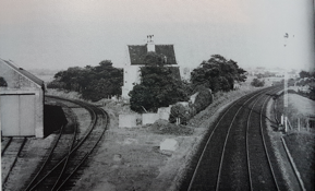
Area Around New Milton Station Viewed From The Water Tower c. 1900
In 1900 the demand for water was such that what is now the iconic tower was built.
The image is from the top of the water tower and shows the view due west along the railway line. Milton Hall, along with the Milton Hotel are clearly visible on the right. To the left of Milton Hall is an empty patch of land. This is where Bank Terrace was built in 1904. As previously mentioned, the Wilts and Dorset bank had left Milton Hall and they moved into a purpose made bank building constructed on the corner of Station Road and Osborne Road. In 1914 Lloyds Bank bought them out.
Naming New Milton – Sub-Post Mistress
In the view from the water tower above the blue triangle shows where the original sub-post office was located. There are no recorded images of it; the building later housed Fred Keeping’s garage. The sub-post office was originally located within the far left-hand section.
[Note the American spelling of ‘Authorized’.]
The sub-post mistress was a Mrs Emma Newhooks who became frustrated that many of ‘her’ parcels ended up at Milton Post Office. The story goes, that in 1896 she applied to the Main Post Office to have the name of her establishment changed to ‘New Milton’, (to differentiate it from ‘Milton’). The request was granted and in 1897 the LSWR followed suite, changing the station name to ‘New Milton’.

1906 image of New Milton post office after it moved to the junction of Station Road and Whitefield Road, by then the post mistress was Mrs Novelle.
There were so many Christmas parcels that they had to be sorted on the pavement.
On the right is the delivery postman, a Mr Patience and Mrs Novelle is holding open a sack. Milton Hotel can be seen across the road bridge.
Fernhill Manor Estate and the Barton Court Estate Develop.
The area continued to develop at a pace. In the 1890s the Barton estates were sold and both farms cut up (New Milton and Barton-on-Sea Official Guide, c.1970s). Access became much easier because the estate gates which blocked off the public from the sea were then removed. There were more sales of land from 1904-1907. A nine-hole golf course was constructed in 1897 along the cliff top east from Barton Court, which became an hotel.
The area flourished from the conventional housing of the Fernhill Manor Estate to the grandeur of Great Ballard – all as a direct result of the coming of the railway.


Fernhill Manor School Great Ballard
Hugh Wyeth’s prediction, that “the area would expand & develop” had already been justified.
(New) Milton Station & Track Layout

The layout of New Milton Station is similar to the other two on the line but by 1898 the layout was extended to add two ‘track crossovers’ thus giving access from the ‘up’ & down’ tracks to both new sidings for unloading & loading goods.

New Milton Station 1898 (‘Courtesy of Ordnance Survey)
To allow monitoring & control of these operations a signal box (S.B. above) was constructed where observation levels were best. The design is one of the L.S.W.R. ‘standard’ versions.


‘Turn Out’ To Sidings Signal Box Coal Office Siding
& Siding & Goods Depot
New Milton Station Buildings
Of the three stations New Milton retains most original features. In particular the roof of the station master’s houses still has the ‘Flemish’ features. The date of construction (1886) is shown using a terracotta-based feature over the door. What was known as Milton Hall can be seen in the background.
The other feature unique to all the Direct Line stations is the distinctive style of wrought iron columns supporting the roofs over the platforms.


Station Master’s House New Milton Wrought Iron Work
Walkford To Hinton Admiral
After the traumas & elevated costs associated with building the line from Lymington Junction to New Milton the next section was easier but involved constructing many bridges and water culverts. These vary from single track to double; as the access to Cater’s Cottage there are numerous examples of large bridges over or carrying narrow tracks.
The line is in relatively shallow cuttings and even the local ‘shanty towns’ at Walkford & Hinton were considered to be peaceful.


Holly Lane Walkford Cutting Walkford Lane
Next Stop Hinton Admiral
After more bridges and through deeper cuttings we arrive at Hinton Admiral Station.
The image below, taken in 1898, shows the station buildings as they were, before ‘modernisation’. The view is from the road bridge looking in the direction of Christchurch. On the ‘up’ platform is a party consisting of the Duke of Connaught and his retinue. Though ‘head codes’ (the three white discs) vary between operating companies it appears to denote an ‘empty train’ probably reserved for the waiting party.

The owner of Hinton Admiral Sir George Eliott Tapps-Gervis-Meyrick, 3rd Baronet of
Hinton Admiral had initially opposed the line. After advice from Russell-Cotes to his wife he relented but insisted on a station being built relatively close to his residence. Furthermore, he negotiated a special condition, that with 24 hours-notice, trains carrying his visitors had to stop at Hinton Admiral station with enough time to allow them and their baggage to board or alight. Given that he owned all the land in the area, the type of development that had occurred in New Milton was inhibited until parcels of land were sold off for housing.
The Direct Line & Highcliffe Castle
With the advent of the Direct Line, kings, queens, emperors and many leading lights used it when visiting Highcliffe Castle; a short distance away from the station.
In 1907 both King Edward Vll and Wilhelm ll the German Emperor (‘Kaiser Bill’) made separate visits to Highcliffe Castle.


The visit of Kaiser Wilhelm was hosted by Major Stuart Wortley with a huge retinue that filled the Royal Bath Hotel in Bournemouth. 7 years later some of the children that cheered him were at war. At the beginning of WW1, the stained-glass window at the Castle given by the Emperor and featuring the German eagle was damaged and soon removed. The postman returned his Fourth Order of The Crown German medal.
At Kingston Lacey, where the Kaiser had planted a tree, housekeeper Henrietta Bankes quickly packed away the bust of the Kaiser which had arrived from the German Embassy a month after the Royal visit. At the time she had been enchanted by Wilhelm.
Cuttings To Embankments
After Hinton Admiral the line west traverses ever deeper cuttings going under the A35 at Roeshot Hill. That bridge there has a concrete ‘Pill Box’, built during WW2.


On through cuttings that still can flood (note the many drain covers) to Goss Road where a 2 ¼ mile embankment starts, finishing at the viaduct over the River Avon.
The embankment is pierced by a whole series of bridges and culverts, many accessing relatively narrow tracks but being of substantial construction.


The embankment required 600,000 cubic yards of material and work on it was delayed by three months due to heavy rain and floods.
Joseph Firbank’s Vision
Though Joseph Firbank Snr. died before the line was completed, his son Joseph T. Firbank, completed the work using his father’s drawings including this outline of the viaduct over the River Avon. The crossing is over what was described as, “the finest salmon pool in the world” with solid ground a full twenty-five feet below the surface of the water. ‘ It starts about 400 yards east of Christchurch Station.

The bridge is made of wrought iron, that does not require painting. The huge weight of the structure meant that the central pier had to be reinforced several times before it was stable. The metal structure is of a similar construction to the Latchmore Bridge and was also supplied by Eastwood & Co, this one at a cost of £10,887 8s 1d.


There were more costs as the disruption to fishing meant the LSWR paid £1200 to the Royalty Fishery.
Closed Ringwood To Christchurch Branch Line
Looking back to the Avon Viaduct from the road bridge by Christchurch we can observe where the now closed Ringwood To Christchurch Branch Line ran. After closure in 1935 the short section running into Christchurch was retained for sidings and the engine shed and old station left in place.
The images below taken in 1965 illustrate these features; now removed.

Engine Shed Old station Viaduct
Sidings ‘Humps’ (retained)
Standing on the same road bridge and turning to the west we see the ‘new’ Christchurch Station that replaced the old one in 1886. In the same year the track between Christchurch and Bournemouth East Station (‘Central’) was doubled in preparation for the opening of the line from Lymington Junction; due to all the build problems it was another two years before that section became operational.


Christchurch Station (final destination of the ‘Direct Line) then on to Bournemouth.
The Truth At Last
LSWR had downplayed the problems to keep their shareholders happy…..”slight difficulties at Sway …” etc.
Once the line was open and operational, more realistic descriptions of the difficulties emerged: –
“there were more problems for the LSWR engineers on this line than [the boggy] Chat Moss had for George Stephenson in 1826”
“of the all the 49 railways built by the main contractor, Joseph Firbank, since 1846 this has proved to be the most troublesome“
The Celebrations – 15th of March 1888
During the morning a special train left London carrying 200 guests, who were then given a carriage tour of Bournemouth followed by a sumptuous lunch with many courses followed by congratulatory speeches. The guests probably suffered indigestion during the return journey as the train left Bournemouth at 4 p.m. sharp.
And what was missing from the day? There was no record of the mention of the ten navvies who were killed and many more with life changing injuries.
Summary – whose line was it, Firbank’s or Jacomb’s?
- 10 miles 33 chains long – 8.5 miles saved.
- Journey time reduced by 30 to 40 minutes
- Cost £670,000 – c. £84 Million at 2020 rates (£10 M. per mile)
- Two Years Late – end date moved from 1886 to 1888
- Bankruptcy of contractors Kellett & Bentley
- Death of & injury to many navvies
- Joseph Firbank (1819 – 29 June 1886) took over the contract on the 1st of August 1885 – his son finished the Direct Line
- William Jacomb died of an apoplexy 26th of May 1887
And the Result?

1895 View of Entrance To Bournemouth Pier
Bournemouth’s population increased from under 16 thousand people in 1881 to over 37 thousand in 1891 and kept on climbing for many years.

Map of the railway developments from 1847 to 1888, extracted from Jude James book, ‘Treacle Mines, Tragedies and Triumph’ (Christchurch: Natula Publications, 2012).
Acknowledgements & Sources
People.
Nick Saunders of Milton Heritage Society for his information & encouragement.
Mike Parry-Evans & John Guy for reviewing the draft ‘Direct Line’ presentation from which this chapter is drawn.
Chris Allsopp for a wealth of data.
Books.
Bradshaw George, ‘1861 Bradshaw’s Handbook’ (Imprint of the original), Glasgow: Collins, 2014)
Coleman T., ‘The Railway Navvies’ (London: Head of Zeus, 2015)
James, Jude, ‘Treacle Mines, Tragedies and Triumph’ (Christchurch: Natula Publications, 2012)
Layson John, ‘George Stephenson The Locomotive & The Railway’, (London, Franklin Classics Trade Press, 2018)
McDermott F., ‘The Life of Joseph Firbank’ (London, Nabu Press, 2013)
Nock O.S., ‘The LSWR’, (Shepperton: Ian Allan, 1971.)
Popplewell, Lawrence ‘Bournemouth Railway History’ (Sherborne: Dorset Publishing Company, 1973)
Young D.S., ‘The Story of Bournemouth’, (London: R. Hale, 1957)
Paper Maps.
Ordnance Survey ‘Maps OL22 New Forest &
195 Bournemouth & Purbeck’ (Southampton, Ordnance Survey 2010).
Mac Maps (Last accessed October 2020).
Newspapers (mainly extracted from ‘Bournemouth Railway History’ (Sherborne: Dorset Publishing Company, 1973)
Advertiser & Times, Poole Pilot, South Western Gazette, Poole & Dorsetshire Herald, The Bournemouth Times, Bournemouth `Evening Echo, The Hampshire Advertiser.
Data Extracted Via Internet Access
Milton Heritage Website (Last searches December 2021).
Maps
Google Maps (Last accessed October 2020).
Ordnance Survey ‘Vintage Maps’ (1898 & 1909) from MHS web site October 2020.
St. Barbe Museum & Hampshire Records Office (Last searches October 2020).
David Heys Steam Diesel Collection, Nige’s Place on Flickr, Pinterest, Wikipedia (Last searched December 2020).
And especially to my wife Samantha for her continuing support & understanding.
Written by Philip Benstead.
6 January 2021.
P.S. My father used to pre-fix his talks on historical topics with, “there are many historic reports but less historic facts”.
If you find any errors or have any complementary data please contact me via the e-mail address above.